Health Data
A registry from Panama's Ministry of Health documents 120 people with albinism across the eight health areas of the Guna Yala region. Here we present that registry, area by area.
About this data
The SOS Albinos Panama Foundation works with a consolidated registry, provided by the Ministry of Health, documenting people with albinism served within each health area of the Guna Yala region. This registry is a key tool for directing health, awareness, and support programs toward the communities that need them most.
Out of respect for the privacy of the people registered — many of them minors, and several in very small communities where any additional detail could identify them — we present only aggregated figures by health area here. No names, ID numbers, ages, or other individual-level data are published.
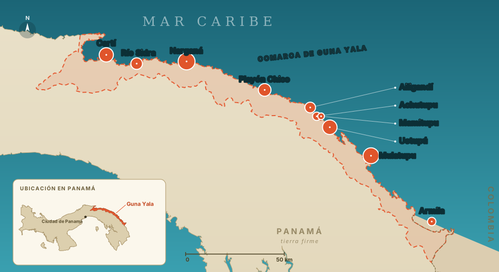
Map of health areas
The Guna Yala region, from west to east, with its registered communities. Each marker's size reflects the number of people with albinism registered there.
Registered by area
Ordered west to east along the coast, matching the map. Figures from the Ministry of Health's consolidated registry.
| # | Health Area | Albinos | Relative | Communities |
|---|---|---|---|---|
| 1 | Cartí Acuatupu · Ailitupu · Cancandi · Cartí Mulatupu · Cartí Sugtupu · Cartí Tupile · Mandiyala · Nalunega · Naranjo Grande · Orostupu · Soledad Mandinga · Tupsuit | 17 | 12 | |
| 2 | Río Sidra Isla Máquina · Mamartupu · Nusa · Río Sidra | 9 | 4 | |
| 3 | Narganá Corazón de Jesús · Maguebgandi · Narganá · Tigre · Tikantikí | 27 | 5 | |
| 4 | Playón Chico Playón Chico · Tupile | 12 | 2 | |
| 5 | Ailigandí Achutupu · Ailigandí · Mamitupu | 11 | 3 | |
| 6 | Ustupú Ogobsucum · Ustupu | 18 | 2 | |
| 7 | Mulatupu Caledonia · Carreto · Cuba · Mulatupu · Navagandi · Sasardi · Tubualá | 23 | 7 | |
| 8 | Puerto Obaldía Armila | 3 | 1 | |
| Total | 120 | 36 |
What the numbers show
Narganá, Mulatupu, Ustupú, and Cartí together account for nearly two-thirds of the registry, with areas like Río Sidra, Playón Chico, and Ailigandí also representing a significant share. This distribution helps the foundation prioritize supply-distribution trips, health partnerships, and awareness campaigns in the communities where the most people with albinism live.
For the historical and legal context behind this population, visit Background & Legal Framework and Law 210.
Help turn this data into real support
Distribution trips, health partnerships, and donations reach these areas directly.
Data: albinism census provided by Panama's Ministry of Health (Ministerio de Salud), compiled into a consolidated registry by health area.
Geography: the national outline and the Guna Yala region boundary are drawn from official administrative-boundary data (Panama COD, humanitarian admin boundaries), simplified for display. Health-center markers are positioned from published coordinates for the island communities; the far-eastern coastline near the Colombian border is approximate.